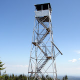
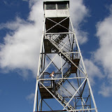
The second hike was Wakely mountain. Parked at the lot off of Cedar River road and started out on the old logging road. There was some beaver activity flooding a section of the trail. The climb up was steep and tiring. We had the summit to ourselves except for a lone chipmunk who drove Howie nuts. I climbed the very tall tower (ten flights of stairs!) for some spectacular views. Two great hikes on a beautiful Fall day.
Summit Elevation: Wakely 3744 ft
Round-trip Distance: 6.0 mi
Elevation Change: 1635 ft
Sunday, September 30, 2007
Doughboy
Howie and I climbed two fire tower peaks on Sunday. The first hike was up Pillsbury mountain. I parked at Sled Harbor and we started up the road. It was a quick trek on the marked trail up to the summit where I climbed the tower to soak up the views. Had a quick lunch break and then headed back down. Only saw three other hikers.
Summit Elevation: Pillsbury 3597 ft
Round-trip Distance: 5.2 mi
Elevation Change: 1730 ft
Summit Elevation: Pillsbury 3597 ft
Round-trip Distance: 5.2 mi
Elevation Change: 1730 ft
Sunday, September 23, 2007
Easy Street
Howie and I did a hike on this perfect first day of Fall in the Adirondack high peaks. We set out from the Loj at 11 AM. Our destination was Street and Nye mountains. There seemed to be a better view from Street than I remember. Nye had no view, like I remember. Trees had some nice color, but not quite peak yet.
Summit Elevation: Street 4166 ft, Nye 3895 ft
Round-trip Distance: 9.0 mi
Elevation Change: 2200 ft
Summit Elevation: Street 4166 ft, Nye 3895 ft
Round-trip Distance: 9.0 mi
Elevation Change: 2200 ft
Friday, September 21, 2007
Holt Preserve
I took the afternoon off and drove to southern Albany County for a short hike with Howie. Our stomping grounds was the Winifred Mathews Holt Preserve. Howie and I walked many of the trails in the preserve, which were mostly woods roads that looped around near the top of Copeland Hill. The lower trails were overgrown and full of scratchy plants. There was also a small, murky pond.
Sunday, September 16, 2007
Crane mountain is the sh*t
I slept in this morning, so that limited my hiking options today. I chose to revisit Crane mountain in the Southern Adirondacks. Even with the late start, it was still cool (56 degrees) when Howie and I reached the trailhead at around 1 pm. The trail to the peak from the south was short, but strenuous. There were a couple of ladders to negotiate. Howie made it up the first one, but opted to climb along the side of the second and longer ladder. There was an expansive view to the south from the summit. I had a sandwich break. Howie got to eat about half of it after I accidentally dropped it on the ground. After the lunch mishap, I headed along the summit ridge where there were several viewpoints - the last one overlooking Crane pond. Continued on the trail down to the pond. Circled around the pond and passed a group of hikers. One dude noticed my Camelback and said that is was the sh*t ... which I guess means that it is good. At the pond outlet, we followed a faint path up to the rocky sub-summit (elevation 2876). There some views to the north from the top of the knob. Returned to the pond and continued down the steep trail. Crossed an unusual natural bridge over a creek (my guidebook mentions a cave). Then reached the old farm road which we followed back to the trailhead.
Summit Elevation: Crane 3248 ft
Round-trip Distance: 5.5 mi
Elevation Change: 1450 ft
Summit Elevation: Crane 3248 ft
Round-trip Distance: 5.5 mi
Elevation Change: 1450 ft
Sunday, September 09, 2007
Running for Bagels
So today, I realized my fitness goal for this summer ... running a 5K (3.1 mile) race. I ran in the Bruegger's Bagel Run in Albany this morning. My goal was to finish in under 30 minutes. I shattered that goal ... with a time of 26 minutes and 26 seconds. And of course, they had bagels for everyone after the race.
Race Results
Race Results
Monday, September 03, 2007
Lyon
Sunday night was not as cold as the previous night. Woke up Monday morning, packed up and then headed over to Lyon mountain for the last hike of the weekend. This was the hardest hike in terms of effort. I pushed myself a bit and was able to make the summit in 1:05. Lyon mountain is in the very northern part of the Adirondacks and has distant views of Montreal to the north, Lake Champlain to the east, and the high peaks to the south. After the hike, I headed back to Albany tired, but satisfied.
Summit Elevation: Lyon 3830 ft
Round-trip Distance: 5.0 mi
Elevation Change: 1790 ft
Summit Elevation: Lyon 3830 ft
Round-trip Distance: 5.0 mi
Elevation Change: 1790 ft
 |
| Lyon |
Sunday, September 02, 2007
Azure
The next hike was Azure mountain. This was a short but moderately strenuous hike. There was a volunteer from the "Friends of Azure mountain" at the top.
Summit Elevation: Azure 2518 ft
Round-trip Distance: 2.0 mi
Elevation Change: 700 ft
Summit Elevation: Azure 2518 ft
Round-trip Distance: 2.0 mi
Elevation Change: 700 ft
 |
| Azure Mountain |
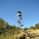
St. Regis Mountain
Sunday morning started out very cold (around 40). It was tough to get out of the sleeping bag. The first hike on this day was St. Regis mountain. This was a moderately strenuous hike near Paul Smiths. There were great views from the rocky summit of the surrounding lakes and mountains. The fire tower is closed (no bottom stairs).
Summit Elevation: St. Regis 2874 ft
Round-trip Distance: 6.8 mi
Elevation Change: 1266 ft
Summit Elevation: St. Regis 2874 ft
Round-trip Distance: 6.8 mi
Elevation Change: 1266 ft
 |
| St. Regis Mountain |
Saturday, September 01, 2007
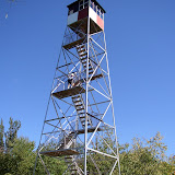
Cathedral Rock
The second hike Saturday was Cathedral Rock. Another easy hike to a fire tower.
Summit Elevation: Cathedral Rock 1725 ft
Round-trip Distance: 2.4 mi
Elevation Change: 185 ft
Summit Elevation: Cathedral Rock 1725 ft
Round-trip Distance: 2.4 mi
Elevation Change: 185 ft
 |
| Cathedral Rock |
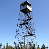
Mount Arab
Our first hike on Saturday was Mount Arab. This was an easy hike. There was a volunteer on the summit to answer questions.
Summit Elevation: Mount Arab 2545 ft
Round-trip Distance: 2.0 mi
Elevation Change: 760 ft
Summit Elevation: Mount Arab 2545 ft
Round-trip Distance: 2.0 mi
Elevation Change: 760 ft
 |
| Mount Arab |
Subscribe to:
Posts (Atom)


