Sunday, November 23, 2008

Berkshire sampler

I led a small group on two short hikes in the Berskshire hills today (near Stockbridge, MA). The first hike was a loop on Monument mountain. The trail climbed moderately through an evergreen forest. We passed Inscription rock and the going got steeper for the final push to the peak. There were nice views at the top on this sunny but cold and windy day. A little tricky coming back down with all the downed leaves.

Round-trip Distance: 2.5 mi
Elevation Change: 600 ft
Monument mountain

The second hike was to Laura's tower. There were several switchbacks which moderated the climb. Went up to the tower, but didn't stay too long with the breezes.

Round-trip Distance: 1.5 mi
Elevation Change: 600 ft
Laura Hill

Tuesday, November 11, 2008

The Pooch of Belleayre

I had today off, so I went hiking with Howie in the Catskills. We climbed Belleayre mountain (a ski resort). Started on Woodchuck Hollow road and followed the blue trail up. It was a gradual climb up an old woods road. There was a lot of bear poo on the trail, but luckily no bears. Reached the lean-to and stopped for a snack. Howie spent the bulk of the break time sniffing around the place. Continued on past the old fire tower site (nothing remains except some foundations) and along the ridge trail to the true summit. There was only a dusting of snow on the ground and nobody around. Took some ski trails back down (Roaring Brook and Cathedral Glen), and then a hiking trail to the old abandonned rail line. Followed the rail line to the road and eventually my car.

Summit Elevation: Belleayre 3429 ft
Round-trip Distance: 7.5 mi
Elevation Change: 1970 ft
Belleayre

Sunday, November 02, 2008

Take me to your leader

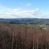
I led two easy hikes today near Middleburgh. The first hike was up Vroman's Nose. It was a short walk to the top up an old carriageway. There were nice views from the ledges on this cool fall day.

Summit Elevation: Vromans Nose 1240 ft
Round-trip Distance: 1.8 mi
Elevation Change: 450 ft

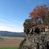
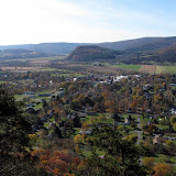
The second hike was up to Middleburgh Cliffs. The road to the top was muddy, and unfortunately looked like it had been widened. There was also evidence of recent logging activity. Reached the top and noticed something odd ... there were power cords and christmas lights strung in the trees everywhere along the ledges. Took a different route down, which was a bit overgrown near the bottom with prickers. Stopped at the Carrot Barn on the way back for a cider donut and coffee.

Round-trip Distance: 3.0 mi
Elevation Change: 640 ft

Vromans Nose (fall)

Middleburgh cliffs