Sunday, October 31, 2010

Nisky

I did some easy walks with Howie this afternoon. First, we stopped at the H.G. Reist Sanctuary in Niskayuna. Did a loop on the core yellow trail and the southern blue trail. The trails were mostly flat and there were lots of leaves down.
The next stop was at Lisha Kill Preserve. We covered all the trails there.
On the drive home, I stopped at Ann Lee Pond near the airport. Did a quick loop there.
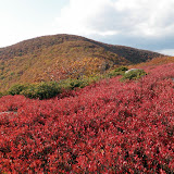
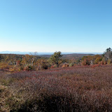
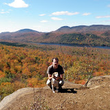
Not a great day for hiking (cold, windy, mostly cloudy and some light showers off and on), but it was good to get outside anyway.
H.G. Reist Sanctuary

Thursday, October 28, 2010

Falling leaves

I took the afternoon off and did a short walk near Thatcher Park. Parked at the trailhead on Old Stage Road. Did a loop that included High Point and Hang glider Cliff. Most of the leaves up on the Helderberg plateau were down. The only color was down in the valley. Walked around 4 miles altogether on this very sunny day.

Saturday, October 23, 2010

Rip's Ledge

I did a short hike in the Catskills today with Howie. Parked at the end Mountain Turnpike road and continued hiking up the old carriage road (Sleepy Hollow horse trail). Got to the site of the former Rip Van Winkle House. From there, it was a short, but steep bushwhack on up (hiking off-trail). I reached the cliffs and the marked path from Winter Clove resort that loops around the cliffs. Had a snack at Rip's ledge and then headed back down. There was still some nice colors on the trees. Didn't see anyone else in the woods on this mostly cloudy day.

Round-trip Distance: 3.5 mi
Elevation Change: 1150 ft

Rips Rock

Sunday, October 17, 2010

Ashokan High Point

I did a hike in the Catskill mountains today with Howie. We climbed Ashokan High Point. Foliage is past peak, but still lots of colors remain. After reaching the top of AHP, I followed the herd path over to Little High Point. We had a real nice day out for our trip.

Summit Elevation: Ashokan High Point 3088 ft
Round-trip Distance: 7.5 mi
Elevation Change: 2450 ft

Ashokan High Point

Monday, October 11, 2010

Mellow Yellow

I did a hike on the Long Path today in Schoharie County (section 30). Parked on Durfee Road and headed south on the aqua blazed trail. The trail went through a small section of the Cotton Hill State Forest, and then dropped down to the "Gorge" where it crossed three small creeks. Some ups and downs as it crossed over a hill. Finally, we reached the cliffs above Middleburgh and stopped for a lunch break. Turned around and headed back to the car. A nice quiet day in the woods.

Round-trip Distance: 7.5 mi
Elevation Change: 1400 ft

Middleburgh Cliffs

Saturday, October 09, 2010

Fall off

Did some easy hiking this afternoon with Howie. First, we climbed Harvey mountain. Got to the top, took a sandwich break and then returned via the yellow trail over Pinnacle Point.

Summit Elevation: Harvey 2060 ft
Round-trip Distance: 4.0 mi
Elevation Change: 700 ft

Next, we did a quick trip up nearby Beebe Hill. There were many leaves down, and the Fall colors not so dramatic. Another picture perfect day though.

Summit Elevation: Beebe Hill 1760 ft
Round-trip Distance: 2.0 mi
Elevation Change: 300 ft

Harvey mountain

Friday, October 08, 2010

The hitchhiker

I did a short walk this afternoon at Thatcher Park. Fall colors are not quite at peak yet (probably 60-70%). The waterfalls were running quite strong after all the rains we have had in the last week. I managed to walk right into a (very) small marriage ceremony on the escarpment trail. Lots of leaf peepers out. Brought home an unintentional hitch-hiker (a tick!). Walked 2-3 miles on this nice sunny day.

Saturday, October 02, 2010

1 + 1 = 10

I did two short hikes with Howie in the southern Adirondacks. The first was up to the cliffs on Balm of Gilead mountain. I parked at the end of Old Farm road (nearly hitting a wild turkey on the drive in). The trails were a bit wet, but you have to expect that after 3-4 inches of rain. Nice views at the top of Thirteenth Lake and the surrounding mountains.

Round-trip Distance: 1.7 mi
Elevation Change: 550 ft

Balm of Gilead


The second hike was Chimney - a neat little mountain with interesting rock formations (including the chimney) and several caves (I didn't go in any). Spent quite a bit of time exploring the summit area. Lots of other hikers out on this fine day.

Summit Elevation: Chimney Mountain 2721 ft
Round-trip Distance: 2.0 mi
Elevation Change: 900 ft

Chimney mountain