 |
| Hannacroix Preserve |
Friday, April 22, 2011
Earth Day
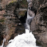
I did a short hike this afternoon at Hannacroix Ravine Preserve. Checked out the waterfall and then followed an informal path along the top of the ravine (east side). Crossed the creek and took the orange trail back. Walked about 3 miles altogether. Had a nice warm day with some sun for a change.
Sunday, April 17, 2011
Barberville Falls
Had a short outing this afternoon to see Barberville Falls near Poestenkill. The 92 foot high waterfall was flowing very strongly. It was breezy out and when the wind kicked up, the mist would surround you. Also, I did a short (~2 mile) hike on the Ridge trail above the falls. The trail was a bit muckety muck (to borrow a phrase) after the recent rains. Be sure to check out the exciting video on YouTube!
 |
| Barberville Falls |
Friday, April 15, 2011
Howie as my Co-Pilot
I took the afternoon off and did a hike with Howie. We climbed Pilot Knob near Lake George. Took the usual pine needle covered path up to the grassy sub-peak. It was a bit cool out, but it was nice to soak up the warm rays on this sunny day. There was still snow in a few patches, but for the most part it was snow-free. After a quick snack at the top, headed back down.
Round-trip Distance: 4.5 mi
Elevation Change: 1500 ft
Round-trip Distance: 4.5 mi
Elevation Change: 1500 ft
 |
| Pilot Knob |
Thursday, April 14, 2011
Bennett Hill
I did a short hike after work. Howie and I climbed Bennett Hill. Nice sunny afternoon. Walked about 3 miles.


Saturday, April 09, 2011
Race to the top
I did a hike on Saturday with Howie in the southern Taconic range. We climbed Mount Race from route 41. Had a nice warm, sunny day for our climb ... T-shirt weather even. Followed the Race Brook trail up past the waterfalls. After the falls, there was 6+ inches of packed snow to navigate through in the pine forest. Got to the saddle between Mount Everett and Race and followed the Appalachian trail south. Not much snow at all on the ridge. Reached the summit and continued down the other side to a line of cliffs. Had nice views to the east into Massachusetts and Connecticut.
Summit Elevation: Race 2365 ft
Round-trip Distance: 5.8 mi
Elevation Change: 1880 ft
Summit Elevation: Race 2365 ft
Round-trip Distance: 5.8 mi
Elevation Change: 1880 ft
 |
| Mount Race |
Friday, April 08, 2011
Partridge Run waterfall tour
I did a hike this afternoon with Howie to check out more waterfalls. Parked on Ravine Road (CR 6) near Sickle Hill Road in the Partridge Run Wildlife Management Area. Started out on the Redbelly snowmobile trail, but ended up just following along the creek. There were a series of small waterfalls and an old stone dam (now breached). Continued following the creek through a pine forest, past a small pond and then finally reached Partridge Run Road. I stopped at the two main waterfalls on the creek along the road. Next, I followed the Wood Duck Trail over to Kingfisher Road. I wanted to check out "The Gulf" - a steep ravine on the map which looked like it might have some falls - and right near the head of the ravine were two nice ones! (which were not mentioned in any book!) The bottom of the ravine was narrow with steep side walls. I scampered back up and followed a path along the ravine (and well above the bottom). I passed a ledge with a view and then went downhill until I reached the edge of state land. I headed back up and returned to the car via the paved road. It would be neat to return and see if there are more waterfalls in the Gulf. Walked about 4 miles while exploring on this cloudy day.
 |
| Partridge Run |
Saturday, April 02, 2011
Schoharie Valley
I checked out some waterfalls and did some short hikes in the Schoharie Valley today. Got to check out Creamery Falls in North Blenheim, Gilboa dam, Mine Kill Falls state park, and Crums falls (falls on Keyser Kill) in Breakabeen.
Also, did a hike to see all the small waterfalls on the tributary to Panther creek. Started at the top on Rossman hill road and hiked down almost to the bottom and then back up. There was still a bit of soft snow in the woods (up to 12 inches and more).
Afterwards, I did a short hike up Vromans Nose near Middleburgh.
 |
| Schoharie |
Subscribe to:
Posts (Atom)


