
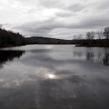
Monday, December 31, 2012
End of year
Did an easy snowshoe hike at Thacher Park this afternoon. Started from the Paint Mine lot and did a loop using various trails (red, blue, orange) in the southern portion of the park.The snow was pretty well packed down which made for easier travels. Covered about 4 miles altogether. Pictured is a small waterall near Hop Field lot.

Saturday, December 29, 2012

Saturday, December 15, 2012
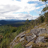
Spruce Hill
Did an easy hike in Massachussets with Howie this afternoon along the Hoosac Range. Parked at the trailhead on Route 2 just past the hairpin turn east of North Adams. Followed the ridge trail to Spruce Hill. The trail was well-constructed with switchbacks, stone steps and bench cuts. There was a dusting of snow in the woods and only a few icy spots on the trail. Needless to say, I slipped on a small patch and fell on my elbow, but fortunately was not hurt. There were nice views along the way and at the summit. Had a cold but very sunny day for our trek. Only saw one other hiker and a dog.
Summit Elevation: Spruce Hill 2566 ft
Round-trip Distance: 5.4 mi
Elevation Change: 800 ft
Summit Elevation: Spruce Hill 2566 ft
Round-trip Distance: 5.4 mi
Elevation Change: 800 ft
 |
| Spruce Hill |
Sunday, December 09, 2012
Rand Mountain
Did a hike in the southern Adirondacks with Howie. Our destination today was Rand mountain. Couldn't drive all the way to the trailhead since Hope Falls road was closed where the pavement ends. So, I parked at the barricade and walked the road. After about a mile near a camp site, I started my bushwack heading in a SE direction. I was able to avoid any cliffs and it was open woods all the way up. After a short but steep climb, I reached the cliffs on the NW side of the mountain and stopped for a break. There were nice views to the west. Continued in a easterly direction until I reached the woods road. Took that to the third falls on Tenant creek. Followed the foot path past the other two falls eventually reaching the road which I took back to the car.
Summit Elevation: Rand 1780 ft
Round-trip Distance: 7.0 mi
Elevation Change: 800 ft

Summit Elevation: Rand 1780 ft
Round-trip Distance: 7.0 mi
Elevation Change: 800 ft
 |
| Rand |

Saturday, December 08, 2012
Champlain Canalway Trail
Walked part of the old Champlain canal trail in Halfmoon (from Upper Newton road to where the improved trail ends 0.75 miles below Brockwood road). It was easy waling on the stone dust path. Passed old remnants of bridge abutments and canal locks and walls. Covered about 5 miles altogether on a foggy, cool day.
 |
| Champlain Canalway Trail |
Sunday, December 02, 2012
Blech
Did a short hike with Howie in the Catskills today. Climbed Overlook mountain near Woodstock. Sloppy walking up the jeep road which had a half inch coating of slush. Reached the summit and was in the clouds. Didn't bother to climb the tower. Ate my bagel sandwich and headed back down. Quite a few other hikers out on this overcast day.
Summit Elevation: Overlook 3150 ft
Round-trip Distance: 5.2 mi
Elevation Change: 1400 ft

Summit Elevation: Overlook 3150 ft
Round-trip Distance: 5.2 mi
Elevation Change: 1400 ft

Saturday, December 01, 2012
Rail Trail 2
Did another section of the Albany rail trail today. Walked from Upper Font Grove Road to Hilton Road. This section had a more rural feel than what I walked last week. About 2.9 miles round-trip under cloudy skies.


Sunday, November 25, 2012
Triple Play
Visited three small nature preserves/parks in Clifton Park. The first stop was North Woods Nature Preserve. Parked at entrance on Shadow Wood Way. Followed the yellow perimeter trail. Easy walking on smooth trails. Passed a small pond which was the former village of Round Lake reservoir. Next stop was the Woodcock Preserve on Tanner Road. Covered all the trails here - main white trail with red and yellow spur trails. Saw a white tailed deer. Last stop was Kinns Road Park. Trails were unmarked, but wide and easy. Covered about 4+ miles altogether on a cloudy, cold day.
 |
| Clifton Park |
Friday, November 23, 2012
Rail Trail
Did a short walk on the Albany County Rail Trail this afternoon. Walked the newly opened section from Fireman's Park (Slingerlands) to Veterans Memorial Park (Delmar). Trail is currently unpaved (crushed stone and dirt). The western section goes through a nice woods, but after that it feels like you are in other people's backyards. Walked about 3.8 miles altogether ... now I can have some more pie.


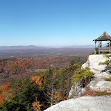
Saturday, November 17, 2012
The Cobbles
Did a hike on the Appalachian Trail in the Berkshires with Howie today. Parked at the end of Furnace Hill road in Cheshire, MA and jumped onto the AT. It was brisk out, but I was quickly feeling warm after a bit of climbing up the trail. The bright sunshine also helped. We soon reached The Cobbles which had nice views to the north,west and south from its cliffs. Continued on the AT all the way to Gore pond. Stopped for a lunch break and then headed back. Did a short bushwhack to a slide that was about 1/3 mile off the trail (and SE of The Cobbles). Looked like a local hangout spot - complete with a stone grill. Had a nice clear, sunny day for our trek. Only saw two other hikers all day.
Round-trip Distance: 6.5 mi
Elevation Change: 1700 ft
Round-trip Distance: 6.5 mi
Elevation Change: 1700 ft
 |
| The Cobbles |
Sunday, November 11, 2012
Pine and Forks mountains
Did a hike in the Adirondacks today with Howie. We climbed Pine and Forks mountains in the Hudson River gorge area. Parked near the bridge over the Boreas river on Northwoods Club road. Started out following the old Tahawus railroad. Then headed into woods and up to the summit of Pine mountain. Explored the ridge along the top which had some nice views down to Hudson river and the surrounding mountains. Continued down to the col and then up the backside of Forks mountain. Checked out some cliffy areas along the south face with views and then headed back down to the railroad. Followed that back to the road. Nice warm sunny day for our adventure.
Summit Elevation: Pine 2103 ft, Forks 1990 ft
Round-trip Distance: 6.0 mi
Elevation Change: 1630 ft

Summit Elevation: Pine 2103 ft, Forks 1990 ft
Round-trip Distance: 6.0 mi
Elevation Change: 1630 ft
 |
| Pine and Forks |

Friday, November 09, 2012
Twofer
Did two easy walks/hikes this afternoon with Howie. First, we climbed Bennett Hill in Clarksville. Followed the green trail to the top and then the yellow loop trail.
Next, went over to Holt Preserve. Did a short loop from the lower parking lot (red-orange-blue-green-yellow-green-red-blue-road). Had a cool, breezy day with some breaks of sun. Walked around 4 miles altogether.

Next, went over to Holt Preserve. Did a short loop from the lower parking lot (red-orange-blue-green-yellow-green-red-blue-road). Had a cool, breezy day with some breaks of sun. Walked around 4 miles altogether.

Sunday, November 04, 2012
Trail Work
Went out to do some trail work today on my section of the Escarpment trail. Raked out the drainage channels. Also, removed some blowdown from the recent storm, but luckily there weren't too many. A fellow hiker helped me dragged a small tree out of the path. After my section, continued on to the summit of Windham. There was a dusting of snow and it felt like a winter wonderland. Kind of cold, blah day.
Summit Elevation: Windham 3524 ft
Round-trip Distance: 6.4 mi
Elevation Change: 1740 ft

Summit Elevation: Windham 3524 ft
Round-trip Distance: 6.4 mi
Elevation Change: 1740 ft

Saturday, November 03, 2012
Van Rensselaer Forest
Did a short walk this afternoon at the Van Rensselaer Forest and Wildlife Preserve in Glenmont. Never heard of this place before, but it is owned by a Protestant Church (First Reformed Church of Bethlehem). Parked on Route 9W just south of Elmwood Cemetery. Walked most of the trails here. The yellow trail was in the worst shape. It had overgrown patches with prickers and rotting bridges. The other trails were fine for the most part - wide and easy walking. Got back to the car and was covered with ticks.
 |
| Van Rensselaer |
Sunday, October 28, 2012
Dunham
Went for an easy hike this afternoon at Grafton Lakes state park. Did a loop around Dunham Reservoir. Parked on Johnson Road near the canoe launch. Followed the Double Bit trail around the west side of the reservoir. Crossed the outlet just below the spillway and continued across the dam. Took the Dunham trail back around the east side. Climbed a small hill just off the trail and scared off two deer. Eventually made it back to car. Walked about 3.5 miles under grey skies.
 |
| Dunham Reservoir |
Saturday, October 27, 2012
Schiffendecker
After Howie's beagle meetup, went for a short walk at Schiffendecker Farm Preserve. Trailhead is on Bender Lane in Delmar. Walked all the trails (yellow, red, blue) in this small, fairly new nature preserve. Some noise from nearby highways (it's behind Walmart/Lowes on 9W), but a nice enough walk.


Friday, October 26, 2012
Howard mountain
I have had this mountain on my hiking radar for a while - mainly because of the name.
Maps showed no marked trails to this small peak, and it wasn't mentioned in any guide book. Aerial images showed a series of cliffs on the south side with the possibility of good views. Today, I decided to give it a go. Parked at the trailhead on Tracy Road (CR 8) in North Hudson. Started out on the Crowfoot Pond trail. At a little over half mile, left the trail and headed south toward the peak. Crossed over a small sub-peak (elev. 1520), and then up to the main summit. Spent some time checking out the different ledges along the south side of the peak. There were nice views, but unfortunately the skies were dark and cloudy. Headed back down. Passed a small beaver meadow and then reached the trail at about the same spot. By this time, the skies of course had cleared and the sun was shining brightly. Continued on the trail to Crowfoot pond. It was easy walking on the old road which doesn't seem to get much use. Reached the pond and noticed a small road heading uphill. Decided to follow it for a ways. It went partway up Stiles Hill, and then petered out. There were some openings in the cliffs where you could get some views. But, we were only a couple hundred feet above the pond, so couldn't see too far. Turned around and headed back to the car.
Summit Elevation: Howard 1713 ft
Round-trip Distance: 8.5 mi
Elevation Change: 1400 ft
Summit Elevation: Howard 1713 ft
Round-trip Distance: 8.5 mi
Elevation Change: 1400 ft
 |
| Howard |
Monday, October 22, 2012
Mohonk Preserve
Played hookie from work and did a hike with Howie today. Went to the Mohonk Preserve near New Paltz, NY. From the visitor center, did a loop hike on various trails (Overcliff Road, Old Minnewaska Road, Short Woodland Drive, Humpty Dumpty Road, Laurel Ledge Road, Undercliff Road). It was easy walking on the old carriageways. Covered around 8-9 miles on this warm, sunny and breezy day. Other than the exorbitant day hiking fee ($12 per person), it was a nice hike.
 |
| Mohonk Preserve |
Sunday, October 21, 2012
Tech Park
Went to Rensselaer Technology Park south of Troy for an easy hike this afternoon. Parked at the Children's Museum lot, crossed the road and walked along the sidewalk. Before the culvert, turned onto a mowed path which lead to a marked trail. The trail went along a small creek, crossed it on a footbridge, and then went back uphill before dropping into another ravine. Continued along the trail and crossed another small creek on a footbridge. Eventually reached the railroad tracks down by the river. Followed the tracks north and then bushwacked back up along the first creek. There were some small waterfalls and cascades. Eventually reached the first foot bridge and took the trail back to the car. Next, I drove over to the PBS television station (WMHT) building and parked in visitor lot. Followed the mowed path through a field to the woods and then the marked trail down to check out more waterfalls. Explored both sides of the ravine. Walked about 4 miles altogether. Howie picked up a few ticks.
 |
| Rensselaer Tech Park |
Thursday, October 18, 2012
Stewart
Did a short walk/hike this afternoon at the Stewart Preserve near Sand Lake. About 2 miles of trails - one main loop (orange) and a side loop (blue). Many leaves already down, but some yellows remain.


Saturday, October 13, 2012
Cedar
I did a hike in the southern Taconics with Howie today. Parked at NY trailhead on Rte 344 in Copake Falls. Started on the Cedar Brook trail and then headed off trail and up hill toward Cedar Mountain. It was open woods most of the way up. My destination was the cliffs at around 1750 ft elevation and not the actual summit. The cliffs were well-protected by scrub oak and mountain laurel. Had to nearly get on hands and knees in some spots in order to push through them to get to the ledges. There were nice views from several different vantage points to the west, south and east. Could look down on Bashbish falls which was a unique perspective. After a snack and picture-taking, headed back down toward the road. Crossed the road and jumped on to the trail to Bishbash falls. There were lots of people about. Returned by the trail back to the car.
Round-trip Distance: 3.5 mi
Elevation Change: 1000 ft

Round-trip Distance: 3.5 mi
Elevation Change: 1000 ft
 |
| Cedar |

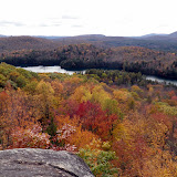
Friday, October 12, 2012
Leaf Peeper
Went to Thacher Park after work this afternoon to check out the Fall colors. Milled around for about an hour.


Monday, October 08, 2012
Lil Cat
Did a hike in the southern Adirondacks today. Parked along Benson road and then followed the unmarked trail to Woods lake. There was a sole fisherman out on the water. Continued around the southeast side of the lake. Then, went off trail and headed uphill (since this mountain has no trail to the top). The woods were mostly open. Reached the summit and took a short break. Checked out several ledges below and west of the summit (around 1800 ft) that had nice views. Headed back down to the car. Was lucky to have some nice breaks of sun on this cloudy, cool day.
Summit Elevation: Little Cathead 2090 ft
Round-trip Distance: 3.5 mi
Elevation Change: 730 ft
Summit Elevation: Little Cathead 2090 ft
Round-trip Distance: 3.5 mi
Elevation Change: 730 ft
 |
| Little Cathead |
Sunday, October 07, 2012
Partridge Run
Went for a quick hike this morning with Howie at Partridge Run WMA in Albany county. Parked on Beaver Road and did a loop on the cross country ski trail (marked with yellow discs). Passed four ponds along the route. Saw a rabbit and some deer. Next, I drove over to Kingfisher Road and explored the Gulf. Went to the cliffs on the east side, and then went over to see the views from the west side. Some nice fall colors today, but leaves already are coming down.
Round-trip distance: 4.0 miles
Round-trip distance: 4.0 miles
 |
| Partridge Run |
Friday, October 05, 2012
Huckleberry
The sun made a brief appearance this afternoon after a week-long hiatus. I ducked out of work early and headed down to the Catskills. Howie and I hiked to Huckleberry Point from Platte Cove road. The trail was a bit wet after all the rains, but not too bad. The skies were hazy, so not great for picture taking once we reached the ledges. Fall colors seemed subdued.
Round-trip Distance: 4.9 mi
Elevation Change: 1100 ft
Round-trip Distance: 4.9 mi
Elevation Change: 1100 ft
 |
| Huckleberry Point |
Saturday, September 29, 2012
Burnt Hill
Did a hike today at Burnt-Rossman Hill State Forest. Started from Westkill Road and went up the Long Path. It followed an old road along Doney Hollow Brook. There were lots of stone walls and foundations along the way. Reached a small pond with some camping spots. Continued on the trail down to Cole Hollow Road. Followed roads for a while and then returned to the car by the Long path again. Weather was not too great - it sprinkled lightly off and on ... mostly on. But, still it was good to get out of the house on a blah day.
Round-trip Distance: 7.5 mi
Elevation Change: 1320 ft
Round-trip Distance: 7.5 mi
Elevation Change: 1320 ft
 |
| Burnt Hill |
Sunday, September 23, 2012
Oh brother
Did a hike in the Adirondacks with Howie today. Climbed two of the three Brothers mountains near Brant Lake. Parked along Palisade Road off of Route 8 and headed into the woods. Followed the state boundary markers (yellow paint) for a short while, and then a rough path marked with red paint and flagging. Stopped at the First Brother which had nice views to the west and south over Brant Lake. The weather was a bit unsettled and it sprinkled for a minute. Continued on to the Second Brother which had no views. Decided to skip the Third Brother and returned back. Didn't see anyone else in the woods.
Round-trip Distance: 4.0 mi
Elevation Change: 1400 ft
Round-trip Distance: 4.0 mi
Elevation Change: 1400 ft
 |
| The Brothers |
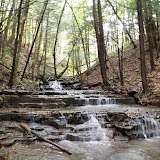
Friday, September 21, 2012
Thacher
Went for a walk at Thacher Park after work. Just a hint of fall colors, but still mostly green. Waterfall had some good flow after the deluge of rain we had this week.


Sunday, September 16, 2012
Stoppel
Howie and I went for a hike in the Northern Catskills this afternoon. We hiked to Stoppel Point starting from Storks Nest Road. It is still pretty dry in the Catskills. No water in any of the creeks or the spring along the trail. Had a nice cool, sunny day for a hike.
Summit Elevation: Stoppel Point 3420 ft
Round-trip Distance: 8.2 mi
Elevation Change: 2270 ft
Summit Elevation: Stoppel Point 3420 ft
Round-trip Distance: 8.2 mi
Elevation Change: 2270 ft
 |
| Stoppel |
Friday, September 14, 2012
Moxie
Did a hike in the central Adirondacks with Howie this afternoon. We climbed Moxham mountain. From the trailhead on Fourteenth road, we followed a newly cut trail (just opened in August). It was surprising that there were three other cars there on a Friday- guess word gets out fast. The trail was mostly duff, and was soft underfoot. It went over a small knob and back down to creek and beaver meadow. Then it gradually climbed up to the ridge. There were many views on the ridge section of the trail to the summit.
Round-trip Distance: 5.0 mi
Elevation Change: 1150 ft
Round-trip Distance: 5.0 mi
Elevation Change: 1150 ft
 |
| Moxham |
Sunday, September 09, 2012
Ragged
Did a hike in North Adams, MA today with Howie. From the first trailhead on Notch road, took the Bellows trail south for about 2.5 miles. It was easy walking on the old road. Then, I followed the short, but steep path up to the southern summit of Ragged mountain. Stopped at the viewpoint for a lunch break. Next, I continued on the herd path for a bit, but I lost it. I just headed in the general direction I wanted to go. Eventually, I hooked back up with another path just before a cave like opening under a jumble of big boulders. I continued on up to the northern knob which had a lot of open rock and a view toward Mount Greylock. Followed the path south to the view over Adams town. I then tried to find the correct path back. I found it, but again I lost it and had to bushwack a short distance back to the southern summit. Returned back to the car via the trail.
Round-trip Distance: 7.0 mi
Elevation Change: 1300 ft
After the hike, I did a short walk to a waterfall (The Cascades). It was dark and difficult to photograph. Had to hold my camera steady against a rock because of long exposure time. The walk to the falls and back was about 1.2 miles round-trip. A nice, cool sunny day for hiking. Oh, and Howie ate a mouse.
 |
| Ragged |
Saturday, September 08, 2012
Wolf hill
Did a short walk/hike this afternoon at the Keleher Preserve (Wolf Hill). The new trails seem to be mostly completed now. Followed the white and blue trails plus a short spur trail (red) to a small overlook. Walked about 2.5 miles total.


Friday, August 31, 2012
Clark
Went for an easy walk at Clark Reservation state park this afternoon in Syracuse. Did a loop using various bits of trails (Mildred Faust, Dry Lake, Big Buck, Long, Pulpit Rock, Cliff and Lake trails). It was a very warm day and Howie enjoyed cooling off in the lake.


Thursday, August 30, 2012
Hike the Huyck
Went to an office picnic this afternoon. Then, I took Howie for a short walk at the Huyck Preserve. Stopped at the falls and then took the trail around the lake. Saw a deer in the woods. The water level in the lake was low. There is a nice, new bridge above the falls to replace the one destroyed by Irene. Nice day for a stroll.


Sunday, August 26, 2012
Pilot Knob
Did a loop hike over Pilot Knob near Lake George. Tried to get an early start to beat the heat. Had the grassy sub-peak, and most of the trails to myself today. Looks like the ranger has covered the unofficial blazes on the trees and rocks with black and grey paint. Stopped at the creek on the way back to soak my feet in a small pool.
Round-trip Distance: 5.5 mi
Elevation Change: 1460 ft

Round-trip Distance: 5.5 mi
Elevation Change: 1460 ft

Saturday, August 25, 2012
Lisha Kill
Did a short hike/walk this morning at Lisha Kill Preserve in Niskayuna. There is now a self guided audio tour with those funny bar codes on signs if you have one of those new-fangled smart phones. Howie met several other dogs including one beagle who was not as friendly as him. Walked all the trails - about 2 miles altogether.


Friday, August 24, 2012

Sunday, August 19, 2012
Pine Cobble
Did a hike with Howie in MA this afternoon. We did a loop over Pine Cobble. Went up the Pine Cobble trail to the rocky lookout. Some nice views, but the skies were kind of grey. Then, I continued on to the Appalachian Trail. Went down the '98 trail. Checked out a small glider wreck just off the trail.
Round-trip Distance: 4.5 mi
Elevation Change: 1420 ft
Round-trip Distance: 4.5 mi
Elevation Change: 1420 ft
 |
| Pine Cobble |
Saturday, August 18, 2012
Canady Hill
Did a short hike in Schoharie County with Howie. Started on Cotton Hill Road and followed the Long Path up the hill and back down to Canady Hill road. Returned by the same route. Saw a couple of deer running about near the top. There were also some people camping in a clearing. Along the trail were a couple of giant ant hills (around 3 to 4 feet in diameter) ... weird. Had a nice cool sunny day for a walk in the woods(4.6 miles).
 |
| Cannady Hill |
Sunday, August 12, 2012
Acra
Did a clockwise loop hike over Acra Point in the Catskills today. The woods are looking better after recent rains. At least there was water available for Howie to drink.
Round-trip Distance: 5.0 mi
Elevation Change: 900 ft
Round-trip Distance: 5.0 mi
Elevation Change: 900 ft
 |
| Acra Point |
Monday, August 06, 2012
Thacher
Did a short walk after work at Thacher Park. Traveled the Indian ladder trail and part of the escarpment trail. Howie sniffed out a chipmunk in the rocks. His howling reverberated against the cliff walls. Had a nice cool, dry evening for our stroll.


Saturday, August 04, 2012
Dipper Brook Falls
Did a hike in the Adirondack high peaks today. Didn't climb any peaks though. Instead, went in search of more waterfalls. Started from the Giant trailhead on Route 73, but didn't take the trail. Instead, I followed Dipper Brook upstream. The water was low and you could just rock hop. After a while, I got tired of rock hopping and headed into the woods. Stayed mostly on the left side of the brook and quite a bit above it. I continued upstream for about half mile. There were two tall falls which were difficult to photograph. I was too far up above the brook and the walls of the ravine were nearly vertical. There was no apparent easy way down on this side, so I continued on up above the main falls. Stopped at a nice little pool for a quick dip. The water was very cold, but refreshing on this hot day. Continued on to Dipper pond and then headed back to the trail. Did a loop over the "Nubble" and then headed back to the car. Saw a couple of beavers swimming around in the Giant Washbowl.
 |
| Dipper Brook Falls |
Friday, August 03, 2012
waterfalls sans water
Went to Christman Preserve this afternoon for a short walk. Not much water going over the falls - just a trickle. And the creek itself was pretty dry except for a few pools of water where the little tadpoles and fishies could hang out.


Sunday, July 29, 2012
Creek walk
Did a short hike at Plotterkill Preserve this afternoon. Started at the new trailhead on Lower Greg road. Followed the fresh cut connector trail in to the red trail (north rim), and then down to the creek. Instead of crossing and following the south rim trail - I followed the creek upstream. Sometimes I walked in or along side the creek, but often I walked up along the banks. Passed about half dozen small cascades until I reached Rynex creek and the main lower falls. Turned around and then headed back up to the rim trail and out. Had a nice 4 mile walk. Oh yes, the falls looked better after we got some much needed rain last week.
 |
| Plotterkill 2 |
Friday, July 27, 2012
Misery loves company
Did a hike this afternoon in the Taconics. Drove up Robinson Hollow way, a steep narrow gravel road, to the parking area. Then, I started out on what I thought was the marked trail. It wasn't ... just an unmarked old logging road. I had my GPS so I couldn't really get lost, so I continued on. Shortly, I got to a fork and took the left branch that dropped down into the hollow. Crossed a creek (which was mostly dry) and started back uphill on another logging road. The road petered out and I then crossed another drainage and hooked up with a different logging road going in the same northerly direction. Eventually, I got onto another road which was level and heading east toward the ridge. I reached an intersection and followed that road up to the ridge. Soon, I was on the Taconic Crest trail (actually a re-routed section of it). I then headed north on the TCT across Misery mountain. Got to the NY and MA markers and turned around. Headed back south on the TCT and then took the correct trail (yellow markers) back down to the parking area. Had a nice unexpected adventure today. Walked about 7.5 miles total.

 |
| MIsery |

Sunday, July 22, 2012
Thacher Park
Did a short walk at northern section of Thacher Park. Started from Old Stage Road trailhead and did a loop hike. Visited both view points on this warm sunny day.


Subscribe to:
Posts (Atom)


