Saturday, September 29, 2012

Burnt Hill

Did a hike today at Burnt-Rossman Hill State Forest. Started from Westkill Road and went up the Long Path. It followed an old road along Doney Hollow Brook. There were lots of stone walls and foundations along the way. Reached a small pond with some camping spots. Continued on the trail down to Cole Hollow Road. Followed roads for a while and then returned to the car by the Long path again. Weather was not too great - it sprinkled lightly off and on ... mostly on. But, still it was good to get out of the house on a blah day.

Round-trip Distance: 7.5 mi
Elevation Change: 1320 ft
Burnt Hill

Sunday, September 23, 2012

Oh brother

Did a hike in the Adirondacks with Howie today. Climbed two of the three Brothers mountains near Brant Lake. Parked along Palisade Road off of Route 8 and headed into the woods. Followed the state boundary markers (yellow paint) for a short while, and then a rough path marked with red paint and flagging. Stopped at the First Brother which had nice views to the west and south over Brant Lake. The weather was a bit unsettled and it sprinkled for a minute. Continued on to the Second Brother which had no views. Decided to skip the Third Brother and returned back. Didn't see anyone else in the woods.

Round-trip Distance: 4.0 mi
Elevation Change: 1400 ft
The Brothers

Friday, September 21, 2012

Thacher

Went for a walk at Thacher Park after work. Just a hint of fall colors, but still mostly green. Waterfall had some good flow after the deluge of rain we had this week.

Sunday, September 16, 2012

Stoppel

Howie and I went for a hike in the Northern Catskills this afternoon. We hiked to Stoppel Point starting from Storks Nest Road. It is still pretty dry in the Catskills. No water in any of the creeks or the spring along the trail. Had a nice cool, sunny day for a hike.

Summit Elevation: Stoppel Point 3420 ft
Round-trip Distance: 8.2 mi
Elevation Change: 2270 ft
Stoppel

Friday, September 14, 2012

Moxie

Did a hike in the central Adirondacks with Howie this afternoon. We climbed Moxham mountain. From the trailhead on Fourteenth road, we followed a newly cut trail (just opened in August). It was surprising that there were three other cars there on a Friday- guess word gets out fast. The trail was mostly duff, and was soft underfoot. It went over a small knob and back down to creek and beaver meadow. Then it gradually climbed up to the ridge. There were many views on the ridge section of the trail to the summit.

Round-trip Distance: 5.0 mi
Elevation Change: 1150 ft
Moxham

Sunday, September 09, 2012

Ragged

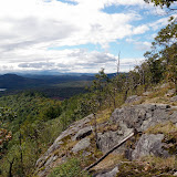
Did a hike in North Adams, MA today with Howie. From the first trailhead on Notch road, took the Bellows trail south for about 2.5 miles. It was easy walking on the old road. Then, I followed the short, but steep path up to the southern summit of Ragged mountain. Stopped at the viewpoint for a lunch break. Next, I continued on the herd path for a bit, but I lost it. I just headed in the general direction I wanted to go. Eventually, I hooked back up with another path just before a cave like opening under a jumble of big boulders. I continued on up to the northern knob which had a lot of open rock and a view toward Mount Greylock. Followed the path south to the view over Adams town. I then tried to find the correct path back. I found it, but again I lost it and had to bushwack a short distance back to the southern summit. Returned back to the car via the trail.

Round-trip Distance: 7.0 mi
Elevation Change: 1300 ft

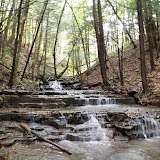
After the hike, I did a short walk to a waterfall (The Cascades). It was dark and difficult to photograph. Had to hold my camera steady against a rock because of long exposure time. The walk to the falls and back was about 1.2 miles round-trip. A nice, cool sunny day for hiking. Oh, and Howie ate a mouse.
Ragged

Saturday, September 08, 2012

Wolf hill

Did a short walk/hike this afternoon at the Keleher Preserve (Wolf Hill). The new trails seem to be mostly completed now. Followed the white and blue trails plus a short spur trail (red) to a small overlook. Walked about 2.5 miles total.