
Monday, May 28, 2012
Virginia
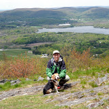
While visiting my sister in northern Virginia the past week, I did a couple short hikes/walks. One was at Riverbend Park and the other at Ellanor Lawrence Park.

Friday, May 18, 2012
Vues magnifiques
I did a short hike this afternoon with Howie near Lake George. From Route 149, I walked north on the bike trail for about a mile. Then, I turned onto the blue-marked trail that lead to the cliffs on west side of French mountain. There were nice views on this very sunny day. On the way down, I stopped at a small brook. Also made a quick side trip to see Colonel Williams monument just off the bike trail.
Round-trip Distance: 3.8 mi
Elevation Change: 760 ft

Round-trip Distance: 3.8 mi
Elevation Change: 760 ft
 |
| French |

Sunday, May 13, 2012
Morning jaunt
Did a short walk at Thatcher Park this morning. Parked at end of Carrick Road. Did a loop. Saw a turkey on the red trail which made Howie go bonkers. Visited High Point and Hang Glider Cliff. Nice sunny day for an outing. Walked about 4.5 miles.
 |
| Thacher Park |
Friday, May 11, 2012
Lenox ridge
I did a hike this afternoon with Howie near Lenox, MA. Parked on Reservoir Road and started walking the old dirt road (Dunbar Road). Turned right onto the gravel access road that lead to the top of Lenox mountain. There were a couple of antenna towers near the summit. Had nice views to the west. Continued hiking on the informal ridge trail. There were many butterflies fluttering about. Stopped at Yokun Seat where there were more views. Then, I headed over Mahanna Cobble which is the top of the Bousquet downhill ski center. Returned by the same route. Nice sunny but breezy day.
Summit Elevation: Lenox 2155 ft
Round-trip Distance: 8.2 mi
Elevation Change: 1300 ft
Summit Elevation: Lenox 2155 ft
Round-trip Distance: 8.2 mi
Elevation Change: 1300 ft
 |
| Lenox |
Sunday, May 06, 2012
"The Burning"
Did a hike today with Howie in Vermont near Manchester. Got to the trailhead off Glen Road and started out on the Lye Brook trail. After 2.3 miles, took the side trail to Lye Brook falls. It crossed a land-slide cause by Hurricane Irene last year. Got to the falls and climbed a short path up on the left to get a better look. Returned back to the main trail and continued on for another mile or so. Here is where the adventure started. I had checked out sattelite images of the area and noticed a large area of rock on the opposite ridge. On the topo maps, this ridge is labeled as "The Burning". Sounded kind of ominous - like a Steven King novel. A google search did not turn up much except an old photo from 1900. I wanted to check it out and see if there were still any views. So, I left the trail and dropped down into the hollow. It was steep (30-40% grade), but not treacherous (no ledges). Got
to the brook and there was a small waterfall upstream. Rock-hopped across the brook and then headed back up the other ridge. It was just as steep heading up this side through the mostly open deciduous woods. I got near the top of the ridge and then headed NW. Reached the first patch of open rock. There were three little snakes here sunning themselves. I didn't notice until I was nearly stepping on them. They slid away. After that little scare, I continued on until I reached the first lower and large area of open rock. The quartzite slabs of rock here were the size of refrigerators or larger. It was a bit difficult to get across as there sizeable gaps between the huge boulders. It was also not beagle friendly territory, so I ended up ducking back into the woods and climbing up to the top of the mass of rocks (to nearly elevation 2600 ft). Crossed here and then continued on the ridge a bit. I skipped the second larger patch of rocks. I contemplated following the ridge all the way back down to the trailhead, but the woods were coniferous at the top and scratchy. I was also making slow progress and figured it would be faster to go back to the main trail. So, I dropped back down into the hollow. Got to the brook and waded across this time as I wanted to soak my feet anyways. Then I headed back up to reach the trail. It was a quick walk out on the trail. Had a nice, partly sunny day for our little adventure. Some bugs were out, but they were not too awful. Crossing the ravine twice added quite a bit of extra elevation change to an otherwise moderate hike.
Round-trip Distance: 8.0 mi
Elevation Change: 2900 ft
Round-trip Distance: 8.0 mi
Elevation Change: 2900 ft
 |
| The Burning |
Subscribe to:
Posts (Atom)


