Saturday, August 24, 2013

Feeling Blue

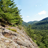
Did some hikes today in the Pharaoh Lakes Wilderness with Howie. First we climbed Blue Hill. Parked on Route 74 and followed the Blue Hill (aka Long Swing) trail for about 3/4 mile. Then, headed off trail and up the west side of the hill. After a short, but steep climb we reached the lower ledges overlooking the beaver pond. Continued on up to the summit. Headed west back down the hill catching more views along the way from the patches of open rock. Made it back to the car, but realized that my jacket was missing. Must have left it somewhere on the hill.

Summit Elevation: Blue Hill 1620
Round-trip Distance: 3.5 mi
Elevation Change: 750 ft

Next, drove a short distance up the road to another trailhead and followed the short (0.3 mile) trail up to Arnold pond. Continued on a unmarked, but obvious path that climbed up the western ridge of Skiff mountain. Many small cairns along the way. Stopped for views near the top, but didn't go to the true summit that was another 1/2 mile east.

 Round-trip Distance: 1.5 mi
Elevation Change: 700 ft
Blue Hill Skiff

Sunday, August 18, 2013

Berry good

Went for a short hike this morning at Berry Pond Preserve. Parked at the Lake George Rec Center and followed the cross-country ski trails to the blue connector trail that lead to the preserve. Did a loop over a small hill that had a couple of view points. Easy walking on old roads. Stayed mostly cloudy, but that also kept it from getting too warm. Didn't visit berry pond on this trip.

Round-trip Distance: 5.0 mi
Elevation Change: 1000 ft
Berry Pond Preserve

Thursday, August 15, 2013

St John Lake Mountain

Took the day off from work and did another hike in the southern Adirondacks with Howie. We explored an unnamed mountain near St. John Lake in the Wilcox Lake Wild Forest. Parked in the ample lot on Harrisburg road and followed the state trail along a sliver of state land. After about 1/3 mile, it ended near the boundary line. Bush-whacked in a NW direction on up the ridge. Stopped at a nice viewpoint just before the top of one of the many bumps on this mountain (with views to west and south). Kept going down to the col and reached the old road shown on the topo maps - which is now just a foot path. Thought about tagging the summit, but there was a lot of spruce thickets on way. Turned around and headed south over to an area of open rock with more nice views (to the west, south and east). Continued down the mountain and eventually reached the car again. Nice cool, sunny day.

Round-trip Distance: 4.0 mi
Elevation Change: 1000 ft
St Johns

Sunday, August 11, 2013

Wardboro road

Did some exploring in the Lake George area today with Howie along Wardboro Road. Parked at an old cemetery and continued walking north along the road. After about 1/2 mile, the improved part of the road ended and it became a snowmobile trail. Followed the road for another mile, and then headed east off-trail. After a short distance (< 1/3 mile), reached some cliffs/ledges above Fly creek across from Middle mountain. While I stopped to take some pics, Howie stealthily ate all my crackers. Headed back to the car the same route.

Round-trip Distance: 4.0 mi
Elevation Change: 600 ft

Drove back to the intersection with Padanarum road. Headed SW up the unnamed hill. Passed an odd stone structure that looked like a well, but was only about 4 feet deep. Maybe it was just to hold surface water? Reached some more ledges and views. Went back down the hill to the east, waded across Northwest brook, and quickly reached the road again. Nice sunny day in the Adirondacks.

Round-trip Distance: 2.0 mi
Elevation Change: 720 ft
Wardsboro road

Sunday, August 04, 2013

Flag Rock

Did two short hikes in the Berkshires today with Howie. First hike was to Flag Rock. Fairly easy climb from the trail-head on Route 183 near Housatonic. Wish I had brought my bug spray as the mosquitoes were biting when I stopped. Nice views to the west from the ledge which was unfortunately covered with graffiti.

Round-trip Distance: 3.8 mi
Elevation Change: 650 ft

Next hike was up East Rock. Started from the trail-head on Quarry St (near Pine St) in Great Barrington. It was a steady climb up. At one point, it rained lightly for a few minutes and then the sun cam back out. I took shelter under a rock overhang. It was a near a ladder which lead to a little view. I continued on the path which became less distinct to the top of East rock. No view from the top that I could find. Headed back down.

Round-trip Distance: 1.6 mi
Elevation Change: 600 ft

Flag Rock