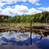
Went for hike today in the southern Adirondacks. Parked at the end of River Road (off Route 30 - north of Northville). Continued hiking on the old road past a campsite and a cabin. After about a mile, I left the road and headed North and up the SE arm of Southerland mountain. I reached the first open area that was only about 450 feet above the Sacandaga river. There were nice views to the east. I continued in a Northwest direction towards the summit. Reached a second open area with good views mostly to the south. After a short climb, I reached the top. It was open and grassy, but there no were no great views. I dropped down to the south and over a small bump to a couple of nice ledges with more views. After a lunch break, I headed back down and eventually reached Groff creek. I headed upstream and checked out a few waterfalls. A couple of them had nice pools at their base. The water was too cold for swimming, but I did soak my feet in once. I made it back up to the old road which I followed for another mile. It eventually reached a beaver pond and the path seemed to fade away. I backtracked, and then headed up the west side of Groff mountain. There were no views at the top, but there was an old hiker patch nailed to a tree. I dropped down the north side of the mountain. I did manage to find some views through the trees along the way. Soon I reached the road again which I followed back to the car. The mosquitoes were out today, but the breezes kept them from being too terrible. Still got quite a few bites - could of used some bug spray. Nice cool, partly cloudy day for an adventure in the woods.
Summit Elevation: Southerland 1920 ft, Groff 1780
Round-trip Distance: 8.5 mi
Elevation Change: 2100 ft


No comments:
Post a Comment