Friday, October 31, 2014

Mysteries of Panther mountain's eastern ridge

Took a day off from work to go exploring in the Catskill mountains. I was looking at satellite images, as one is wont to do. I noticed a peculiar clearing about a mile east of Panther mountain on a little wart on its eastern ridge (elevation 2848). What created this clearing? Aliens? Zombies? I thought it was large enough that it might have some views even though it was a flat area. I decided to go check it out. I parked on Panther Kill Road just past a bridge at an unmarked area to pull-off (about a mile from Woodland Valley Road). I headed south up the ridge following a drainage and then started veering more westerly. It was mostly deciduous woods and fairly easy to navigate with the bulk of the leaves down. I reached a smaller clearing and then the large clearing. It was about 1-2 acres in size and had a thin layer of poorly drained soil with mosses, grasses and low shrubs. There was a close-up view of the summit of Panther to the west. Could also see the rest the Borough's range (Slide, Cornell, Wittenberg) above and through the trees. I explored a little more and found some partial views to the north from some ledges. I climbed a small boulder (glacial erratic) toward the back of the field and had some snacks. It was eerily quiet. I was half expecting the alien ship to touch down. I packed up and headed back. Took a little longer route going over the small bump to the east (elevation 2560). On the way down, I stumbled onto a nice woods road which eventually led to a couple of camps down by the road.

Round-trip Distance: 5.0 mi
Elevation Change: 1900 ft
Panther East Ridge

Sunday, October 26, 2014

I've been walking on the railroad

Did an easy walk today with Benny on the Albany Rail Trail. Walked the section from Hilton Road to Voorheesville Ave. About 2.3 miles round-trip on a breezy, gloomy afternoon. On the drive back, stopped at a farm stand and got a pumpkin.


Saturday, October 25, 2014

Plantain and Ashley

Climbed two small trail-less peaks in the southern Taconics (Berkshires) today. The first was Mount Plantain - name after the New England plant, not the banana like fruit. I parked at a trailhead on East Street - about a mile from the MA/CT border. The land east of the road is a conservation easement (Nature Conservancy). I followed the entrance logging road for about 10 min. Then turned right at a junction onto another logging road for another five min. (This road eventually leads to the AT near Sages Ravine.) I left the road and headed east uphill toward the northern end of the peak. It's only about 1/3 mile as the crow flies, but I am not a bird. So, I was not able to fly over the tangled mass of mountain laurel that covers this side of the mountain. Eventually I reached the top and it was much easier going. There was a lot of open grassy areas, but no great views - just a couple of views over the trees. I headed back down a different route (more to the south). Luckily, I picked up a hunters path which I followed for a while until I lost it - not far from the logging road though. It was a lot quicker to come down than going up.

Summit Elevation: Plantain 2088 ft
Round-trip Distance: 2.5 mi
Elevation Change: 425 ft

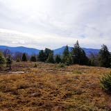
After reaching the car, I went across the street and climbed Mount Ashley. I headed almost due west until I reached the ridge. Then I turned south and followed the ridge to the peak. It wasn't too bad going. There were some swaths of mountain laurel along the way, but you could usually skirt around them on one side of the ridge or the other. They were interspersed with open, lightly wooded areas covered with grasses and ferns - mostly dead now and doing a good job of hiding all the rocks and other tripping hazards. It was a bit thick closer to the summit, but I think I just chose a bad route. Again, there were a few views over the trees - mostly to the east. After tagging the top, I backtracked back to the car.

Summit Elevation: Ashley 2390 ft
Round-trip Distance: 2.5 mi
Elevation Change: 720 ft
Plantain Ashley

Sunday, October 19, 2014

Look Deep into Nature

Visited two "new-ish" nature preserves in Rensselear County this afternoon with Benny. The first stop was Robert Ingalls Nature Preserve. The trailhead is on Garfield Road just west of Horse Heaven Road. There is a short trail (marked with yellow), that leads down to Black Brook and then loops back up. Less than 1/2 mile walk.

Next stop was at the Mud Pond Preserve. Trailhead is on Central Nassau Road (just east of Mud Pond Road). Followed the main trail (yellow markers) to the pond overlook, and then the Haley Farm trail (red markers). Added an additional 1.7 miles of walking on a cool, breezy day.
Rensselaer County

Friday, October 17, 2014

A Walk in the Woods

Left work a little early and did an easy walk with Benny at Schenectady County Forest Preserve near Delanson. We did a loop on the main blue trail, plus another loop on the newer green trail located at the back of the property. Lots of leaves down, but there still were some yellows hanging on. Walked about 2.8 miles on this late afternoon.
Schenectady Forest

Sunday, October 12, 2014

Bald

Went for hike in the Southern Adirondacks today. Climbed Bald mountain near Warrensburg. It is one of the Three Sisters. I had previously climbed the Middle Sister in the Spring. The last sister is Pine mountain (home of Hickory Ski Center). Parked at the end of Katts Corners Road. Followed the old snowmobile trail for about two miles. Where it split, I took the left branch that led up hill. After a short while, I left the trail and then headed up the southern side of Bald mountain. It was steep near the top and I ran into some cliffs. I thought I was hallucinating as I could hear voices that sounded close by. I headed around the west side of the peak and found an easier way up. Ran into a few kids that I had heard from below. The summit is surrounded by a semi-circular ring of ledges with views to the west, south and east. I explored the top and all the different viewpoints. I decided to go down a different (easier) route. Headed north and soon picked up an old eroded logging road. I followed it for a bit to an odd clearing. It seemed to be veering east, so I left it and continued down hill. I picked up another old trail farther down that led me straight back to the snowmobile trail. Then, it was a quick walk back to the car. Beautiful day out.

Summit Elevation: Bald 1980 ft
Round-trip Distance: 6.5 mi
Elevation Change: 1400 ft
Bald

Saturday, October 11, 2014

Thacher

Took Benny to Thacher Park this afternoon to check out the foliage. Walked along the Indian Ladder Trail and part of the Escarpment. About 1.75 miles of walking. Lots of leaf peepers out today.
Thacher Fall 14

Friday, October 10, 2014

A walk in the Park

Went for a hike in the Adirondacks today. Climbed Park mountain in the Pharaoh Lake Wilderness (near Schroon Lake). Started from the Pharaoh Road trailhead off of Beaver Pond Road. It was a bit brisk (46 F) in the morning, and I needed to put on a couple of layers. From the parking area, I continued walking along the road/trail for about 0.8 miles. Then, I turned left (west) onto an old road that follows the south side of Mill Brook. It was mostly clear (just a few blowdowns) and easy to follow. The road bed was well defined - even if you lost it momentarily you could find it again soon enough. After about 2.0 miles, I left the road and headed up the north side of Park mountain. It was open woods all the way up. Closer to the top, the terrain was steeper with a lot of moss covered rocks - slippery when coming back down. There were views to the west from a lookout near the summit (toward Schroon Lake). I continued on to the southern knob which had views to the south (toward Beaver Pond). Fall colors are past peak in this region, but there is still some nice pockets of color in the valleys.

Summit Elevation: Park 2011 ft
Round-trip Distance: 6.6 mi
Elevation Change: 1300 ft
Park mtn

Sunday, October 05, 2014

Let it Beebe

Did a couple of easy hikes with Benny this afternoon in Columbia County. First, we did a hike up to the fire tower on Beebe Hill. Passed a bunch of people on the trail, but had the top to ourselves oddly enough. Walked around 1.8 miles with 350 feet of climbing.

Next, we stopped at the Schor Conservation Area. Followed the trails around the pond and on up to the overlook. Walked about 1.5 miles with 250 feet of climbing. A lovely Fall day for a walk-about - cool and with lots of bright sunshine.
Beebe

Friday, October 03, 2014

Off my rocker

Went for hike in the southern Adirondacks today near Wells. Parked at an unmarked pull-off on Gilmantown Road just past the bridge over Elbow Creek. Followed an old road for about 100 feet to the creek. Looked like a nice camping spot, but there was a "no camping" sign there. The road seemed to end here. I crossed the creek and headed up towards Mount Overrocker. The woods were mostly open deciduous trees with some witch hazel to contend with. Crossed a couple of old logging roads on the lower slopes. Reached the top and continued down the south side. There was a nice ledge just a short distance SW from the top. Could see Mt Orrey to south and Round mountain to the west. Then, it was a sharp drop down as I continued down to the col. I climbed the next un-named peak which didn't offer any views. Then I headed more westerly toward Round mountain. Dropped down to the col and the beaver pond nearby. Crossed a hunters path. Then it was a short but steep climb up to the top of Round. There were a couple of open, rocky areas. But, they were not sloped enough, so the trees blocked a lot of the view. I found what I figured was the true summit and then headed back down to the car.

Summit Elevation: Overrocker 2132 ft, Round 2431
Round-trip Distance: 5.5 mi
Elevation Change: 1700 ft
Overrocker

Thursday, October 02, 2014

Holt

Went for a short hike/walk this evening with Benny at the Holt Preserve in Feura Bush. From the trailhead on Lower Copeland Hill Road, did a loop consisting of various colored trails. After stopping at the pond, followed the road back to the car. Walked about 1.5 miles altogether. In other news, it's tick season again. Pulled three deer ticks off Benny when I got home.