Monday, May 25, 2009

Hike like an Egyptian

I climbed Pharaoh mountain in the Adirondacks today with Howie. From the trailhead on Route 74, I took the Long Swing trail (Blue Hill trail) to Crane pond and then continued on the red-marked trail to the summit. There were not too many people out in the woods. There were a lot of mosquitos though ... the nasty kind that would find the one place you didn't put bug repellent. At the top, cool breezes and lots of sunshine.

Summit Elevation: Pharaoh 2556 ft
Round-trip Distance: 12.0 mi
Elevation Change: 1860 ft

Pharaoh

Friday, May 22, 2009

PK 2


I took the afternoon off and headed up to Lake George with Howie. We did a loop over Pilot Knob following the "marked" path to the grassy sub-peak, and then followed the drainage back down to the main trail.

I also checked out Stewarts Ledge which is an overlook on the NW shoulder of Pilot Knob. I wasn't sure where the trail started. I followed one obvious path which lead up to the ledges and past some overlooks. Another path lead back down below the cliffs and back out to main trail.

Round-trip Distance: 5.5 mi
Elevation Change: 1460 ft

Friday, May 15, 2009

It's gonna be huge!

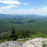
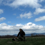
or Giant in this case ... which is the mountain I climbed today with Howie. It's one of the easier climbs in the Adirondack high peaks. Conditions were very good: weather-wise (cool and sunny with a breeze), trail-wise (just a little wet and muddy in spots), bugs-wise (apparently taking the day off). There was a little of snow left in spots near the top, but most of it had melted. Seemed like I was twice as old as everyone else on the trail today. Don't know if that's good or bad. In any case, had a great day on the trail.

Summit Elevation: Giant 4627 ft
Round-trip Distance: 6.0 mi
Elevation Change: 3050 ft
Giant

Sunday, May 10, 2009

Berlin

I did a hike in the Taconics with Howie this afternoon. Climbed Berlin mountain from Southeast Hollow. Followed the trail (an old logging road) up to the ridge, and then took the Taconic Crest trail north over several bumps. It was very windy out. We saw a turkey (I think) walking on the trail. It took to flight as we got closer. Reached the grassy summit and took a few pics. It was a bit cool and windy on top, so I didn't linger too long. As I headed back, the skies cleared out and the sun was shining. Only saw three other people in woods today.

Summit Elevation: Berlin 2798
Round-trip Distance: 8.4 mi
Elevation Change: 2100 ft

Berlin mountain

Saturday, May 09, 2009

Trail U

I took Trail Maintenance 101 class today at North-South Lake campground (Catskills). The first part was oral instruction on how to do trail maintainance. The second part was field work on a short section of the Escarpment trail (using loppers and pruners). Covered pretty basic stuff that I mostly knew. Also, I adopted another short section of trail.

Friday, May 08, 2009

If you don't like the weather, just wait...

I did a short hike/walk with Howie this afternoon. We visited the Huyck Preserve in Rensselaerville. Took in the main waterfall and then followed the trail around Lake Myosotis. A couple of guys were fishing along the edge of the lake. The weather started out cloudy with some very light drizzle, but then the clouds cleared out and the sun was shining brightly. Got home and planted flowers.


Saturday, May 02, 2009

Meow

I did an easy hike near Lake George with Howie. From the trailhead, we started out on an old logging road. If you stopped for too long, the bugs would start swarming around you. It motivated me to keep moving. Reached the top of Cat where there nice views of the lake and surrounding mountains. Had a quick lunch, took some pics and then followed the relatively new ridge trail over to Thomas mountain. A porcupine ran up a tree and waited for us to pass. Went over some small bumps along the ridge and then made the final ascent of Thomas mountain. A small cabin is located at the top near a rock ledge. Followed another road back down and then out to the car. Much sunnier out than forecast.

Summit Elevation: Cat 1956
Round-trip Distance: 7.0 mi
Elevation Change: 1600 ft

Cat and Thomas