Saturday, December 28, 2013

The Bundler

I put together three hikes today in Columbia County. The first was at Drowned Lands Swamp Conservation Area. We hiked up the Summit Trail to the top of the hill. There was a bench to sit and enjoy some views through the trees. Also took the Swamp Trail at the base of the hill.

Round-trip Distance: 1.5 mi
Elevation Change: 325 ft

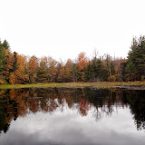
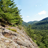
Next stop was at Round Ball mountain conservation area. Took the green trail around the hill with a short side trip on the blue trail. Then, I followed the red trail up to the summit. There were a couple of views through the trees. Returned to the green trail and completed the loop.

Round-trip Distance: 2.0 mi
Elevation Change: 420 ft

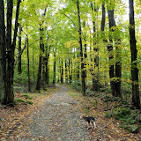
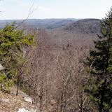
The last hike was at Rudd Pond State Park. Parked on Shagroy Road and followed the trail around Ore Pit Pond. There was a small waterfall at the east end. Took a path up the hill to a dirt road. Followed the road/trail along the creek past an old dam. At the split, took the left branch trail and continued along until it dropped back down near the entrance of the campground. Followed the road through the camping area and then a foot trail back to complete the loop.

Round-trip Distance: 3.3 mi
Elevation Change: 440 ft

Before heading home, I stopped at the Harney and Sons tea shop in nearby Millerton.
Also, all photos are with my new camera (Sony NEX 3N).
Columbia County

Sunday, December 01, 2013

Landis

Went for a short walk this afternoon at Landis Arboretum in Esperance. Did a loop using various trails (Willow Pond, Acorn, Bass, Ancient Forest, Woodland). Walked about 3 miles altogether. Saw lots of animal tracks in the snow. Pictured is the Great Oak tree that was struck by lightening.

Friday, November 15, 2013

Windham

I went out today and did maintenance on my section of the Escarpment trail. Mostly just raked out the waterbars/ diversion channels (around 10 of them). Got to end of my section and turned around. There were a lot of moths flying around in the afternoon. Walked about 5.2 miles altogether. Nice to be back out in the woods. Howie was in full chipmunk hunting mode.

Sunday, October 20, 2013

East mountain

Did a hike in the Berkshires today with Howie on the Appalachian Trail. Parked on Brush Hill Rd (Homes Rd) in Great Barrington.  Followed the AT up to the East mountain plateau. Stopped at a couple of ledges with good views to the west and south. Continued on the AT to the shelter and then returned. A lot of little ups and downs along the way. Beautiful day out. Most leaves are down, but still some oranges hanging on.

Round-trip Distance: 7.0 mi
Elevation Change: 1000 ft
East mountain SF

Tuesday, October 15, 2013

Number eight is great

Did a short hike this morning with Howie. We climbed Number Eight mountain in the Pharaoh lake wilderness of the Adirondacks. Started from the trail-head on Pharaoh road. Followed the trail/road for about 10 minutes, and then started bushwacking up the west side of the mountain. I was proud of myself that I navigated up and down without using the GPS. (I had it on to record my track, but I wasn't using it.) I mostly just followed the terrain, and checked periodically my compass heading. Tagged the summit and then took a break at the grasssy view area below the top. While heading back, I followed a flagged path for a while, but it veered south presumably heading to someones camp. Not a great day for photography (mostly cloudy and grey), but there was still some nice fall colors in the valley below.

Summit Elevation: Number 8 mountain 1946 ft
Round-trip Distance: 3.5 mi
Elevation Change: 1000 ft
Number Eight

Saturday, October 12, 2013

Piseco

Did two small hikes in the Adirondacks near Piseco Lake today. First climbed Mount Francisco - named after one of Verplanck Colvin's surveying assistant (along with Blake and others). There was no trail to the top so this was a bushwhack. Started at a pull-off on Route 8 (marked as sand pit on the topo map). Picked up an old woods road at one point for a short bit. Easy navigating through mostly open deciduous forest. Nice views from open areas south of the summit. Fall colors were past peak and there many leaves already down, but there were still some yellows and oranges left.

Summit Elevation: Mount Francisco 2316 ft
Round-trip Distance: 2.5 mi
Elevation Change: 550 ft

Next climbed Fish mountain. Started from the cemetery at the end of Fish mountain road. It was a short but steep climb up to the top through open woods. Nice views from the ledges south of the summit. There was a memorial there to Michael Lorette (1982-2005) - complete with flag and solar powered lights. Great day out.

Summit Elevation: Fish mountain 2473 ft
Round-trip Distance: 1.5 mi
Elevation Change: 700 ft
Francisco and Fish

Saturday, October 05, 2013

Stamford

Did some hiking in the Northwest Catskills today with Howie. First, we hiked up Bald mountain near Stamford. This is home to the former Scotch Valley ski resort (now abandoned). Parked on Route 10 at the DEC headquarters. Took various road/trails to the top. They were marked sporadically. I was glad to have a crude map. It was mostly gentle climbing up the hill until the last couple hundred feet. Then we reached the top of the ski lifts. The views were not too great on this gray overcast day, and the fall colors seem blah this year. Took a different route down. Headed straight down the lift line to the mid-station. Then, cut over across the mountain. Had to pass through a horse pasture at one point.

Summit Elevation: Bald mountain 2720 ft
Round-trip Distance: 4.5 mi
Elevation Change: 830 ft

Next, went to Clapper Hollow state forest. Followed the trails to the lean-to and returned. About 3.0 miles altogether.
Stamford

Friday, September 27, 2013

Rooster Comb

Did a short hike in the Adirondack high peaks this morning to check out the Fall colors which are near peak. Unfortunately, the weather forecast was a bit off and it ended up being mostly cloudy instead of sunny. Howie and I climbed Rooster comb from the big parking lot on Route 73. Checked out both the summit and the valley overlook and then returned. Quite a few hikers headed up as we were heading back down.

Summit Elevation: Rooster Comb 2762 ft
Round-trip Distance: 5.0 mi
Elevation Change: 1700 ft
Rooster Comb

Sunday, September 22, 2013

Grafton

Did an easy walk this afternoon at Grafton Lakes State Park. Parked at Babcock Lake road trailhead and took the road to White Lily Pond. Then I followed some new mountain bike trails. They wandered around aimlessly and I ended up looping back at the parking area. Was trying to get to the Spruce Bog trail, but I didn't have a map of these new trails. So then I drove over to the Long Pond trailhead and took the Fire Tower trail to the tower on Dickinson Hill. Some fall colors starting to show on this cloudy, breezy day. Covered about 4.5 miles altogether.
Grafton

Saturday, September 14, 2013

Rooney Hill

I climbed unnamed hills near Rooney Hill in the southern Adirondacks (near Wells) with Howie today. Parked at the end of Hernandez Road and followed an old woods road for about 1/4 mile. Left the road which loops back to the parking lot. Began the bushwack up the ridge. Followed along the ridge over a couple of small bumps to the last one which had a nice open view to the south and west. Continued south to the highest bump (elevation 1630). Skipped going to what's labeled as Rooney Hill on the topo map (it's only 1380 feet and is wooded). Instead, dropped back down to the drainage and followed that. Picked up a hunter's path about 1/2 mile from the car and then the loop road again. Nice cool, partly sunny afternoon.

Summit Elevation: Rooney Hill 1630
Round-trip Distance: 4.0 mi
Elevation Change: 950 ft
Rooney Hill

Sunday, September 08, 2013

Dippikill

Went cabin camping this weekend at Dippikill. On Saturday, did a loop hike over Dippikill mountain and then down to the pond and back. About 4 miles altogether.

On Sunday, I went up to recover my jacket that I lost on Blue Hill two weeks ago. It was were I thought I had left it - at the top of the cliffs over looking the beaver pond. On the way down, I stepped on a ground hive and got at least four stings. Didn't go to the summit on this trip, so this was a short hike (~ 2.5 miles).

Dippikill

Saturday, August 24, 2013

Feeling Blue

Did some hikes today in the Pharaoh Lakes Wilderness with Howie. First we climbed Blue Hill. Parked on Route 74 and followed the Blue Hill (aka Long Swing) trail for about 3/4 mile. Then, headed off trail and up the west side of the hill. After a short, but steep climb we reached the lower ledges overlooking the beaver pond. Continued on up to the summit. Headed west back down the hill catching more views along the way from the patches of open rock. Made it back to the car, but realized that my jacket was missing. Must have left it somewhere on the hill.

Summit Elevation: Blue Hill 1620
Round-trip Distance: 3.5 mi
Elevation Change: 750 ft

Next, drove a short distance up the road to another trailhead and followed the short (0.3 mile) trail up to Arnold pond. Continued on a unmarked, but obvious path that climbed up the western ridge of Skiff mountain. Many small cairns along the way. Stopped for views near the top, but didn't go to the true summit that was another 1/2 mile east.

 Round-trip Distance: 1.5 mi
Elevation Change: 700 ft
Blue Hill Skiff

Sunday, August 18, 2013

Berry good

Went for a short hike this morning at Berry Pond Preserve. Parked at the Lake George Rec Center and followed the cross-country ski trails to the blue connector trail that lead to the preserve. Did a loop over a small hill that had a couple of view points. Easy walking on old roads. Stayed mostly cloudy, but that also kept it from getting too warm. Didn't visit berry pond on this trip.

Round-trip Distance: 5.0 mi
Elevation Change: 1000 ft
Berry Pond Preserve

Thursday, August 15, 2013

St John Lake Mountain

Took the day off from work and did another hike in the southern Adirondacks with Howie. We explored an unnamed mountain near St. John Lake in the Wilcox Lake Wild Forest. Parked in the ample lot on Harrisburg road and followed the state trail along a sliver of state land. After about 1/3 mile, it ended near the boundary line. Bush-whacked in a NW direction on up the ridge. Stopped at a nice viewpoint just before the top of one of the many bumps on this mountain (with views to west and south). Kept going down to the col and reached the old road shown on the topo maps - which is now just a foot path. Thought about tagging the summit, but there was a lot of spruce thickets on way. Turned around and headed south over to an area of open rock with more nice views (to the west, south and east). Continued down the mountain and eventually reached the car again. Nice cool, sunny day.

Round-trip Distance: 4.0 mi
Elevation Change: 1000 ft
St Johns

Sunday, August 11, 2013

Wardboro road

Did some exploring in the Lake George area today with Howie along Wardboro Road. Parked at an old cemetery and continued walking north along the road. After about 1/2 mile, the improved part of the road ended and it became a snowmobile trail. Followed the road for another mile, and then headed east off-trail. After a short distance (< 1/3 mile), reached some cliffs/ledges above Fly creek across from Middle mountain. While I stopped to take some pics, Howie stealthily ate all my crackers. Headed back to the car the same route.

Round-trip Distance: 4.0 mi
Elevation Change: 600 ft

Drove back to the intersection with Padanarum road. Headed SW up the unnamed hill. Passed an odd stone structure that looked like a well, but was only about 4 feet deep. Maybe it was just to hold surface water? Reached some more ledges and views. Went back down the hill to the east, waded across Northwest brook, and quickly reached the road again. Nice sunny day in the Adirondacks.

Round-trip Distance: 2.0 mi
Elevation Change: 720 ft
Wardsboro road

Sunday, August 04, 2013

Flag Rock

Did two short hikes in the Berkshires today with Howie. First hike was to Flag Rock. Fairly easy climb from the trail-head on Route 183 near Housatonic. Wish I had brought my bug spray as the mosquitoes were biting when I stopped. Nice views to the west from the ledge which was unfortunately covered with graffiti.

Round-trip Distance: 3.8 mi
Elevation Change: 650 ft

Next hike was up East Rock. Started from the trail-head on Quarry St (near Pine St) in Great Barrington. It was a steady climb up. At one point, it rained lightly for a few minutes and then the sun cam back out. I took shelter under a rock overhang. It was a near a ladder which lead to a little view. I continued on the path which became less distinct to the top of East rock. No view from the top that I could find. Headed back down.

Round-trip Distance: 1.6 mi
Elevation Change: 600 ft

Flag Rock

Thursday, July 25, 2013

Oliver!

Too nice of a day for office work ... went for a hike with Howie instead. Did a bushwack hike in the Adirondacks. Parked on Hoffman road in a small pullout before Oliver pond. Headed into the woods and in a southerly direction toward Oliver Hill. Passed a nice beaver pond along the way. The woods were mostly open, but most of the trees were young and there was a lot of underbrush in spots. Reached the summit of Oliver Hill and then continued a bit south to a small ledge with a view. There were other ledges, but the views were partially blocked by trees. Headed west and reached the ledges along the western side. There was one especially nice spot that had great views ... there were even some blueberries here. Picked my way down through the band of cliffs and ledges as I headed toward Snyder Hill. Grabbed a few raspberries along the way. It was a bit scratchy for the traverse ... glad I wore long pants. There were some views just west of Snyder Hill summit. Headed back down toward the road and it was an easy walk back to the car.

Summit Elevation: Oliver Hill 2470
Round-trip Distance: 6.5 mi
Elevation Change: 1500 ft
Oliver Hill

Sunday, July 21, 2013

Eleventh mountain

Did a hike in the central Adirondacks with Howie today. Visited some cliffs/ledges on the southern side of Eleventh mountain. Followed the Siamese pond trail for about 0.4 miles. Then it was a short,steep climb up to the first ledge. Continued along the escarpment and checked out several different ledges - each had similar  view. After about 3/4 of a mile, I dropped back down to the trail which I followed all the way to the lean-to. Got to soak my tired feet in the East branch. Nice summer day.

Round-trip Distance: 8.5 mi
Elevation Change: 1100 ft
Eleventh

Friday, July 12, 2013

Little Buck

Did a short hike with Howie this morning near Lake George. We climbed Little Buck mountain - Buck mountain's northern brother. There is no trail to the top so this was mostly a bushwack. Started from campsite 11 on Shelving Rock road. Followed along the right side of the creek up to the col and then turned right toward the summit. Continued a short distance west to a nice view point. Tried to keep following along the ridge in a northwest direction. There was one last view point at around 1100 feet elevation. After a snack break, headed north down to Shelving rock falls. Followed the short trail to the road and the road back to the car. Passed another falls along the way where I stopped to soak my feet. A real nice day out for our short adventure.

Summit Elevation: Little Buck 1605
Round-trip Distance: 4.5 mi
Elevation Change: 1200 ft
Little Buck

Sunday, July 07, 2013

No Bull

I visited my sister in Virginia over the July 4th holiday. We did a short hike up Bull Run mountain on Thursday. From the main trailhead, went up Chestnut Ridge trail to the High Point overlook. Nice views to the west from the cliffs. Came back down the Ridge Loop trail, Dawsons trail, and Mountain road. Other activities included museum visits, canoeing, biking and some short walks.

Round-trip Distance: 5.0 mi
Elevation Change: 850 ft

Virginia

Saturday, June 29, 2013

Trail work

Went out today and did some maintenance on my trail on Windham. The trail was in pretty good shape. While doing some clipping at one point, I accidentally cut through Howie's leash with pruning shears.  Later in the day, I met a mountain biker who said that he used to maintain the same trail. Turned out to be a nice day weather-wise - even though the forecast did not look too promising.

Thursday, June 20, 2013

Prospect Rock

Did a short hike with Howie near Manchester, VT this morning. Parked at the end of Rootville road and then continued walking on the road to Prospect Rock. Went for another mile to the junction with the Branch Pond trail. Turned around and headed back. Stopped at another viewpoint on the way down (a short unofficial spur trail lead to it). Nice sunny day in the Green mountains.

Round-trip Distance: 5.0 mi
Elevation Change: 1270 ft

Prospect Rock

Saturday, June 15, 2013

Starbucks

This post is about mountains, not coffee. There actually is a Starbuck mountain in the Adirondacks. Climbed this trail-less peak with Howie. Parked on Route 28 near Cleveland road and headed into the woods. Within a few minutes, I picked up a well defined path which I followed. Reached Raquette brook and there was a plank of wood to cross it. Continued on the path past a power-line cut and then reached some cliffs. Looked like a popular rock-climbing spot. Followed the path on the right to the top of the cliffs. No views at the top of them. I continued on up the mountain. There were no more paths, so this was bushwacking time. I was getting close to the upper cliffs, but it was getting too steep and I didn't see any easy way up. So, I dropped back down to the valley between Starbuck and Black mountains. Reached the creek that drains Black mountain pond. There was a field of stinging nettles to cross in this wet area. Made it through those and followed the creek uphill to the notch. Then I headed west up the mountain. Finally reached the top of the upper cliffs. There were several ledges with great views looking east, south and west. Could see Snowy mountain way off to the west. After soaking in the views, I headed up to the true summit. Not much to see there. Made my way back down.

Summit Elevation: Starbuck 2556
Round-trip Distance: 3.0 mi
Elevation Change: 900 ft

After the first hike, I climbed Hackensack mountain in Warrensburg. Parked at the trailhead on Prospect street. The area was a little confusing with a maze of logging trails. I actually started out on the wrong trail. After realizing it was unmarked, I back-tracked and then found the correct one. It was a short, but steep climb to the top. Took a few pics and headed down. On the return, I took a different trail past a beaver pond. Nice warm, sunny day. Bugs not too bad - mostly mosquitoes in the lower areas.

Summit Elevation: Hackensack 1357
Round-trip Distance: 2.5 mi
Elevation Change: 570 ft
Starbuck

Sunday, June 09, 2013

Spruce

Did a short hike in the southern Adirondacks today with Howie. Climbed Spruce mountain (the one next to Hadley mountain). Parked on Lens Lake road near state land. Headed into the woods in a easterly direction. Dropped down to a creek and then up the western ridge. In less than a mile, I picked up an "unofficial" path marked with orange spray paint. Followed that up to a nice open viewpoint looking west/south and north. Continued on to the summit and then another ledge with a view to the east. The forest changed to spruce and the path became more of a trail marked with colored discs (red and blue). I followed it for ways as it dropped down the northern ridge. Guessing that it heads to someones camp. Turned around before I got too far down, and headed back. Great day out. Some mosquitoes were out, mostly in the lower swampy areas.

Summit Elevation: Spruce 2650
Round-trip Distance: 4.5 mi
Elevation Change: 1100 ft

Spruce

Tuesday, June 04, 2013

The hills are alive

Did a hike in Adirondacks with Howie today. Climbed some small trail-less hills in the Pharaoh Lake Wilderness area. Started from Sucker Brook trailhead. Soon after signing in at the register, I left the trail and headed up to Pine Hill. I quickly reached a couple of nice view points to looking west. Continued along the ridge to Orange Hill which didn't have much in the way of views, and onto to Franks Hill. There were several ledges west of the summit with views to the west/north/south. Stopped for a lunch break and headed to Number seven hill. Near the summit, I almost stepped on a baby deer. It got up and started crying. Within seconds, the mother returned and was making huffing noises. I got out of there and dropped back down to the trail. Took the trail back to the car. Great day out in the woods. Cool, breezy and sunny. And no bugs, except a couple of mosquito bites.

Summit Elevation: Pine Hill 1519, Orange Hill 1642, Franks Hill 1660, Number 7 Hill 1620
Round-trip Distance: 6.8 mi
Elevation Change: 1300 ft
Pine Orange Franks Hill

Friday, May 31, 2013

Plotter Kill

Did a short hike this morning at Plotter Kill Preserve. Started at the Lower Greg Road entrance and took the trail down to the end of the preserve. Then, I followed the along creek upstream all the way to the Upper falls. Took the trail back to the car. It quickly got warm out today, but was considerably cooler in the gorge. Water was almost warm enough for a swim.
Plotterkill

Tuesday, May 28, 2013

Sweet

Did two hikes in the Adirondacks today with Howie. First, climbed Sweet Fern Hill in the Hammond Pond wild forest area. Took the trail to Hammond Pond. After a mile of easy walking on the old road, I reached the outlet of the pond. Crossed the outlet, and then started a bushwack up to the top of the hill. There were some cliffs that I had to find a way around. Soon I was rewarded with views of the pond below and the surrounding mountains. Continued on to the summit. There were many open areas along the way. Not much to see at the top. Headed back down a different route. Caught some more view points. At the bottom of the hill, I reached a beaver pond on the brook. I then just followed along parallel to the brook and soon reached the road. It was then a short walk back to the car.

Summit Elevation: Sweet Fern Hill 1460
Round-trip Distance: 3.5 mi
Elevation Change: 520 ft

It was still early, so I climbed Severance Hill near Exit 28. Fairly quick climb to the top and back down.

Summit Elevation: Severance Hill 1638
Round-trip Distance: 2.2 mi
Elevation Change: 770 ft
Sweet Fern Hill

Monday, May 27, 2013

Canajoharie

On the drive back home, I stopped to see the falls on Canajoharie creek in Canajoharie. Parked at the end of Floral St. and took the short path down to a couple of small falls in the lower gorge. Then, I drove up the hill to Wintergreen park and took the Scenic Trail along the top of the gorge to the wooden overlook. The view of the falls and gorge below was obstructed by leaves on the trees, but it was still a nice walk there and back (about 1.25 miles round trip).

Canajoharie

Sunday, May 26, 2013

Auburn

While visiting Auburn this weekend, I did two easy walks with my Dad. The first was at a relatively new nature preserve at the south end of the lake - Owasco Flats. Parked at the end of Fire Lane 1 off Route 38 near Moravia. Took a 1.6 mile trail around the wetland area. The first leg followed along the inlet of the lake and was a bit muddy in spots. The second leg was along the an old railroad bed and road. Completed the loop by walking the gravel road back to the car - another 0.4 miles or so.
The next day we did walk at the Cayuga Community College nature trails behind the campus. About a mile loop mostly on the  main perimeter trail. Saw a deer take off near the pond.

Auburn

Friday, May 17, 2013

Iron Man

Howie and I climbed Iron mountain (AKA Elizabethtown No. 2) in the Adirondack high peaks. It is a trail-less mountain in the Giant mountain Wilderness area. Parked in small pull-off on Route 9. Started out following an old woods road. It was going in the general direction I wanted to go. Kept on it for nearly a mile, and then headed off trail. From here on, it was a fairly easy bush-whack. There were areas of open rock alternating with deciduous woods. A couple of the rocky knobs along the way were a bit tricky to climb, and I had to find easier ways up them (usually on the less steep northern side). Continued on the ridge taking in the views until I reached the summit. Headed back a slightly different route (more in the woods and away from the rock) and soon picked up the road again. After that, it was smooth sailing back to the car.

Summit Elevation: Iron mountain 2400
Round-trip Distance: 4.5 mi
Elevation Change: 1840 ft

 Had some extra time after the first hike. So, I did another short hike just down the road. Followed the ADK trail to Gilligan mountain. On the way down, Howie had a close encounter with a porcupine. He got within a foot of being quilled. Luckily, I was able to pull him away.

Round-trip Distance: 2.2 mi
Elevation Change: 750

Overall, a nice partly sunny day for our hike. There were a few bugs, but not too bothersome.
Iron mountain

Sunday, May 12, 2013

Blue Ridge

There are a handful of Blue Ridge mountains in the Adirondacks. I climbed the one in the Silver Lake Wilderness near Benson. Parked on Godfrey Road, and started out hiking the Northville-Placid trail. It was a bit cold in the morning (49 degrees), overcast and sprinkling lightly on and off. After about 3.5 miles on the trail, I headed off trail and up the mountain. It was open woods most of the way. I reached some cliffs east of the summit. By now, the weather was starting to clear up. There was a bunch of spruce and blow-down near the top of the cliffs.  Was able to manage to squeeze through and get some decent views. Headed up and over the summit and down to the western cliffs. Again, the cliffs were guarded by a dense spruce thicket. Took some more pics and then headed back down. Turned out to be a perfect hiking day - cool, breezy and no bugs at all!

Summit Elevation: Blue Ridge 2860
Round-trip Distance: 10.0 mi
Elevation Change: 1600 ft
Blue Ridge Mountain

Sunday, May 05, 2013

Bennett Hill

Did a short walk/hike up Bennett Hill this afternoon. Great day with lots of sun, warm temps, refreshing breeze and no bugs. Saw a handful of other people enjoying the nice weather.

Friday, May 03, 2013

Three-fer

Did a hike in the Adirondacks today with Howie. We climbed three small peaks in the Pharaoh Lakes Wilderness area. Parked on Rte 74 and started out on the Short Swing Trail. After a mile or so, I left the trail and headed up Ragged mountain. Short, but steep climb to the ledges with some nice views. Continued along the ridge then down the other side. I kept going through the open coniferous woods, and up to Potter mountain. Took a longer route than expected, but eventually made it to the ridge. Had a nice ridge walk with large open areas and good views. It was getting warmer out, and the bugs came out. But luckily, they were not biting. Went down the west side and back to the trail. Took the trail for a mile or so, and then followed a marked path up to the summit of Bear mountain (marked with small discs with PLC). Turned around and headed back down to the car. Nice day with lots of sunshine. And I found another birthday balloon in the woods!

Summit Elevation: Ragged 1506, Potter 1864, Bear 1647
Round-trip Distance: 8.0 mi
Elevation Change: 1720 ft
Ragged Potter Bear

Sunday, April 28, 2013

State Brook

Did a hike with Howie today  in the Southern Adirondacks. We climbed State Brook mountain. There are no trails going up, so this was a bushwhack hike. Parked along Route 10 and started out. Open woods for the most part. Found a "happy birthday" Mylar balloon along the way. Some stubborn snow in a few spots on the northern side of the mountain. Went to the cliffs NNW of the summit. Heard voices down below. There were some rock climbers. Then I headed up and over the summit and down a bit to another cliff/viewpoint. Stopped for a lunch break and then headed back down to the snow mobile trail. Soon reached the car again. Very warm out on this sunny Spring day.

Summit Elevation: State Brook 2540
Round-trip Distance: 4.0 mi
Elevation Change: 1200 ft

State Brook