Sunday, October 20, 2013

East mountain

Did a hike in the Berkshires today with Howie on the Appalachian Trail. Parked on Brush Hill Rd (Homes Rd) in Great Barrington.  Followed the AT up to the East mountain plateau. Stopped at a couple of ledges with good views to the west and south. Continued on the AT to the shelter and then returned. A lot of little ups and downs along the way. Beautiful day out. Most leaves are down, but still some oranges hanging on.

Round-trip Distance: 7.0 mi
Elevation Change: 1000 ft
East mountain SF

Tuesday, October 15, 2013

Number eight is great

Did a short hike this morning with Howie. We climbed Number Eight mountain in the Pharaoh lake wilderness of the Adirondacks. Started from the trail-head on Pharaoh road. Followed the trail/road for about 10 minutes, and then started bushwacking up the west side of the mountain. I was proud of myself that I navigated up and down without using the GPS. (I had it on to record my track, but I wasn't using it.) I mostly just followed the terrain, and checked periodically my compass heading. Tagged the summit and then took a break at the grasssy view area below the top. While heading back, I followed a flagged path for a while, but it veered south presumably heading to someones camp. Not a great day for photography (mostly cloudy and grey), but there was still some nice fall colors in the valley below.

Summit Elevation: Number 8 mountain 1946 ft
Round-trip Distance: 3.5 mi
Elevation Change: 1000 ft
Number Eight

Saturday, October 12, 2013

Piseco

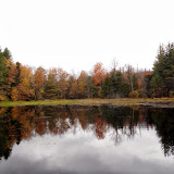
Did two small hikes in the Adirondacks near Piseco Lake today. First climbed Mount Francisco - named after one of Verplanck Colvin's surveying assistant (along with Blake and others). There was no trail to the top so this was a bushwhack. Started at a pull-off on Route 8 (marked as sand pit on the topo map). Picked up an old woods road at one point for a short bit. Easy navigating through mostly open deciduous forest. Nice views from open areas south of the summit. Fall colors were past peak and there many leaves already down, but there were still some yellows and oranges left.

Summit Elevation: Mount Francisco 2316 ft
Round-trip Distance: 2.5 mi
Elevation Change: 550 ft

Next climbed Fish mountain. Started from the cemetery at the end of Fish mountain road. It was a short but steep climb up to the top through open woods. Nice views from the ledges south of the summit. There was a memorial there to Michael Lorette (1982-2005) - complete with flag and solar powered lights. Great day out.

Summit Elevation: Fish mountain 2473 ft
Round-trip Distance: 1.5 mi
Elevation Change: 700 ft
Francisco and Fish

Saturday, October 05, 2013

Stamford

Did some hiking in the Northwest Catskills today with Howie. First, we hiked up Bald mountain near Stamford. This is home to the former Scotch Valley ski resort (now abandoned). Parked on Route 10 at the DEC headquarters. Took various road/trails to the top. They were marked sporadically. I was glad to have a crude map. It was mostly gentle climbing up the hill until the last couple hundred feet. Then we reached the top of the ski lifts. The views were not too great on this gray overcast day, and the fall colors seem blah this year. Took a different route down. Headed straight down the lift line to the mid-station. Then, cut over across the mountain. Had to pass through a horse pasture at one point.

Summit Elevation: Bald mountain 2720 ft
Round-trip Distance: 4.5 mi
Elevation Change: 830 ft

Next, went to Clapper Hollow state forest. Followed the trails to the lean-to and returned. About 3.0 miles altogether.
Stamford